|
Issued January 8, 2003: IT HIT 52 DEGREES ON PARK POINT ON JANUARY 7, AND 54 ON JANUARY8,2003!!!!!!!
DESTROYING THE OLD RECORDS AT THE AIRPORT OF 43 AND 47.
Issued January 22, 2003: The coldest air of the season so far, -35 in Embarrass.
Here are some other locations that got the coldest air:
Downtown Ely (bwca.cc's station): -20
Gunflint Lodge (bwca.cc's station): -22
Littlefork -23
Ely Airport -24
Crane Lake -24
Cook -24
Kabatogama -24
Babbitt -29
Tower -31
Embarrass -35
FEBRUARY 3-4 SNOW EVENT
February 20, 2003: Ice covering
Lake Superior
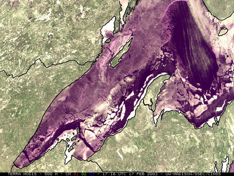
February 21, 2003: A rare lake effect snow event hit Duluth and Superior with
6-8 inches of snow. The snow band was about 4 miles wide. A cold northeast wind is the cause.
February 24, 2003: Another very cold morning
-31 Tower, MN
-31 Embarrass,
MN
-32 Bottineau, ND
-35 Williston,
ND
March 5'th, 2003
A cold March Morning, proving to be (suprisingly) THE COLDEST TEMPS OF THE SEAON
-30 Williston, ND
-30 International Falls, MN
-30 Marcell, MN
-31 Bottineau, ND
-31 Cook, MN
-31 Littlefork, MN
-38 Lake Metigoshe, ND
-39 Tower, MN
Some areas probably -40 below
March 16, 2003:
Record high of 60F degrees at Duluth Airport
Many areas in northeast Mn and northwest Wi hit temps in the 55 to 65 degree range
from March 14 through 16. (Friday through Sunday)
Right along Lake Superior temps were only 27 to 40 degrees, though Superior
hit 59 on the 16th.
MARCH 23, 2003:
Very warm temps, highs in the mid 60's with a few 70 degree readings.
Near the lake, highs around 35
MARCH 28, 2003
A MAJOR STORM SYSTEM THAT WAS SOPPOST TO STAY SOUTH OF DULUTH / SUPERIOR HIT THE AREA
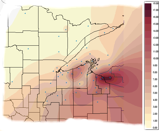
HEAD ON, WITH 10 TO 18 INCHES OF SNOW IN DULUTH, AND 23 TO 30 INCHES ALONG THE SOUTH SHORE OF LAKE SUPERIOR.
| Duluth NWS |
10.1 inches |
| Two Harbors |
8.5 inches |
| Grand Marais 12W |
8 inches |
| Bearskin Lodge |
6 inches |
| Gary New Duluth |
12 inches |
| Fond Du Lac |
12 inches |
| Bruno |
6 inches |
|
|
| Near Poplar |
11.5 inches |
| Cornucopia |
24 inches |
| Grand View |
14 inches |
| 3W Bayfield |
22 inches |
| Cable |
11 inches |
| Park Falls |
8.5 inches |
| Hayward |
3 inches |
| Spooner |
5 inches |
| Mouth of Brule |
12 inches |
| Glidden |
7 inches |
| Mellen |
25 inches |
| Upson |
16 inches |
| Hurley |
20.5 inches |
| Pence |
22 inches |
APRIL 3, 2003
50mph-60mph winds cause minor property damage and giant waves on Lake Superior.
APRIL 4, 2003
Lake effect snow in Duluth accumulated to 10 inches in some areas, along with 40mph winds.
|